North Fork Montour Run
North Fork Montour Run
Project Details
| Original Construction Year | 2008 |
| Most Recent Rebuild Year | |
| Total Cost | 0.00 |
| Total Capital Cost | $0.00 |
| Latitude / Longitude Method | Unknown |
| Latitude | 40.474444 |
| Longitude | -80.277778 |
| Elevation | 0 |
| Project | North Fork Montour Run |
| Project Type | Passive Treatment System |
| Project Status | |
| AMD Source | Underground |
| Stream | North Fork Montour Run |
| Watershed | |
| River Basin | Ohio |
| Quad | Clinton |
| City/Township | Findlay Township |
| County | Allegheny |
| State | PA |
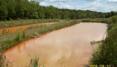
Description: A passive system was installed to treat an underground mine discharge which was impacting the North Fork of Montour Run. The project incorporated the use of 3 ponds built by the PA Turnpike Commission during construction of the Findlay Connector
| Treatment Technology | Quantity | Status |
|---|---|---|
| Aerobic Wetland | 1 | N/A |
| Anoxic Limestone Drain (ALD) | 1 | N/A |
| Settling Pond | 3 | N/A |
| Sludge drying bed | 1 | N/A |
| Vertical Flow Pond (VFP) | 2 | N/A |
|
Map GPS Directions |
| Contact Person: |
| Contact Organization: Montour Run Watershed Association |
| Project Designer: Tim Danehy |
| Project Designer Organization: BioMost, Inc |
| Project Responsible Organization: Montour Run Watershed Association |
| Title | Source | Amount | Date |
|---|---|---|---|
| Matching Funds - Partners | In-kind Contributions | $47,794.00 | |
| OSM Watershed Cooperative Assistance | OSM Watershed Cooperative Assistance | $100,000.00 | |
| PA DEP Growing Greener | PA DEP Growing Greener | $337,367.00 | |
| PA Turnpike Commission | In-kind Contributions | $189,120.00 | |
| Private/Foundation | Private/Foundation | $236,914.00 |
| Project Performance |
|---|